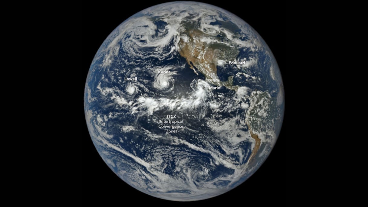
Three hurricanes are churning across the Pacific Ocean at the same time as a strengthening El Niño raises concerns about more extreme weather in the months ahead.
Hurricane Marie formed late Wednesday off the coast of Baja California after Tropical Storm Marie strengthened into a hurricane. It joined Hurricanes Karina and Lowell, both Category 4 storms, which were moving westward across the Pacific.
Three tropical cyclones occurring simultaneously in the region are “definitely rare to see,” Julia Cole, a climate scientist at the University of Michigan, told AFP. She said El Niño warming creates favorable conditions for strong storms because they are fueled largely by unusually warm waters in the tropical Pacific.
Read also : El Niño is back: How a warming Pacific could reshape the world
Lowell was about 725 kilometers south of Hilo, Hawaii, and was expected to remain a major hurricane for several days as it moved west, according to the National Hurricane Center. The agency warned that swells generated by the storm could produce life-threatening surf and rip currents in parts of the Hawaiian Islands.
Karina had weakened slightly while moving northwest but was expected to remain a hurricane for the next several days.
Marie was about 600 kilometers southwest of the southern tip of Baja California, generating swells along parts of southwestern Mexico and the Baja California Peninsula. Those swells were expected to reach Southern California over the weekend.
The three-storm formation comes as El Niño intensifies. The World Meteorological Organization said there is a nearly 100% chance that the climate pattern will continue through February 2027 and is expected to strengthen before reaching its peak toward the end of this year.
WMO Secretary-General Celeste Saulo warned that the phenomenon could become stronger than any El Niño observed since modern monitoring began.
Read also : Weather: WMO warns El Niño set to intensify between August and October
El Niño is the warming phase of the El Niño-Southern Oscillation, a natural climate pattern that occurs every two to seven years. It develops when east-to-west trade winds weaken, allowing warm water that normally accumulates in the western Pacific to move eastward and rise to the surface.
The warmer ocean provides additional energy for tropical storms. El Niño can also reduce vertical wind shear over the Pacific, making it easier for hurricanes to strengthen.
Warm waters provide fuel for storms, while El Niño’s effect on the atmosphere reduces vertical wind shear over the Pacific, creating conditions favorable for hurricanes to intensify, Benjamin Kirtman, an atmospheric scientist at the University of Miami, told AFP. He said the climate system has “significantly warmed” over the past two decades and noted that sea-surface temperatures in the region were already near record highs.
Read also : Mediterranean warming could intensify thunderstorms and disrupt air travel, study warns
A similar concentration of tropical systems occurred in 2015, another strong El Niño year, when Typhoon Kilo, Hurricane Ignacio, Hurricane Jimena and Tropical Depression 14E were simultaneously active across the Pacific.
The WMO has warned that the strengthening El Niño could increase the risk of droughts, floods and other extreme weather events through 2027.