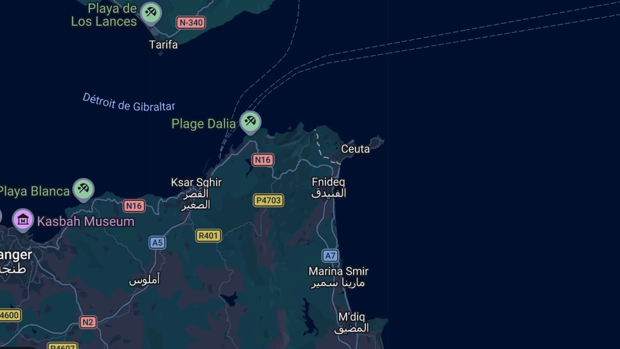
Spain’s Popular Party has taken a years-old dispute over Google Maps to Brussels. European Parliament member Juan Ignacio Zoido has submitted a written question to the European Commission, asking it to intervene with Google over the way its mapping service marks Ceuta and Melilla’s borders with Morocco with gray dashed lines.
For Zoido, a former Spanish interior minister who now sits with the European People’s Party, the way the border is drawn places the two occupied presidios in the category of “disputed territories” and conveys what he considers misleading information about the border between Morocco and Europe.
Zoido wants to know whether the Commission is aware of how Google Maps depicts the two cities and whether it intends to use the Digital Services Act to demand that the company change it. “Ceuta and Melilla are not disputed territories. We must be uncompromising on these issues,” he told Spanish daily ABC, calling for an “immediate correction.”
Read also : Morocco tightens Ceuta approaches, intercepts 142 in pre-dawn push
The PP lawmaker claims that the two cities are the only territories administered by an EU member state whose borders are depicted in this way by Google. He also cites Spain’s 1985 Act of Accession to the European Communities, as well as recent statements by European Commission President Ursula von der Leyen.
Zoido’s initiative, however, conflates two separate issues. The first is the status that Spain and the European Union assign to Ceuta and Melilla. The second is how a private company chooses to depict on its maps a territorial dispute between two states.
What the dashed line actually means
Google Maps does not explicitly label Ceuta and Melilla as “disputed territories.” What it does is show a dotted grey line along their land borders with Morocco, whereas the borders between Spain and Portugal or Spain and France, for example, are shown as solid lines.
The distinction is more than cosmetic. Google’s official mapping guide states that undisputed international borders are shown as solid grey lines. Dotted lines, by contrast, are used for provisional boundaries, treaty boundaries whose legal course has not been definitively settled, de facto boundaries and disputed borders.
In the latter case, Google says that “the parties involved do not agree on the boundary.” The line used around Ceuta and Melilla therefore means that the platform does not present those borders as fully recognized by all parties.
The line has no legal force. It nevertheless reflects the existence of two opposing official positions over the territory, without taking sides in the dispute.
Read also : Ceuta: From Algerian digital interference to the ‘Makhzen’s’ hand, José María Gil Garre’s startling U-turn
Google itself reaffirmed that principle last August when questioned by Maldita. The company said it remained “neutral on geopolitical debates” and sought to depict “disputed territories objectively.”
The multinational said it consults information from “cartographic authorities around the world,” including the United Nations. It did not, however, specify which source it relied on in the case of Ceuta and Melilla, or when it decided to depict them in this way.
Zoido’s portrayal is therefore open to question. Google does not deny that Spain effectively administers the two cities, nor does it assign them to Morocco. What the platform shows is that Spain and Morocco hold different positions over their sovereignty.
A border marking that predates July
Some social media users have circulated claims that Google changed its map of Ceuta and Melilla after the mass crossings of July 30 and 31, 2026. That is false. The dotted line did not appear in response to those events. It has been on the platform for years.
The depiction can be traced back to at least May 14, 2020. On that date, a user asked on Google’s support forum why the land borders between Spain and Morocco were shown as dotted lines.
The issue resurfaced with greater attention in 2023. Local outlet Ceuta al Día published images showing Ceuta and Melilla outlined in the same way and compared Google’s depiction of the cities with the lines it uses for Crimea, Kashmir and Transnistria.
The history goes back even further. ABC reported as far back as 2018 that users accessing Google Maps from Morocco saw no border at all around Ceuta and Melilla.
Google adjusts certain names and boundaries depending on the country from which its service is accessed, particularly where geopolitical disputes are involved. The platform, for example, offers different versions of the same map in territories such as Crimea, varying its boundaries according to the user’s location and the rules in force in each market.
When new posts in August 2026 attributed the dotted lines to the events of the previous month, both Maldita and Newtral confirmed that the boundary had appeared on the platform for years. The only thing that has changed is the politics. The PP has chosen to take before the European Commission a complaint that Google was already aware of—and one on which the company has so far declined to act.
The dispute the map does reflect
Zoido argues that Google’s depiction contradicts United Nations criteria because Ceuta and Melilla do not appear on the UN list of Non-Self-Governing Territories. It is true that neither city is currently on that list. That does not mean, however, that Morocco’s claim does not exist, or that it has never been raised before the international organization.
Read also : Ceuta: PP and Vox’s anti-Morocco crusade suffers a stinging defeat in European Parliament
Morocco formally brought the matter before the Special Committee on Decolonization in January 1975. In document A/AC.109/475, the Kingdom’s permanent representative requested that Ceuta, Melilla, the Al Hoceima rock, the Vélez de la Gomera rock and the Chafarinas Islands be added to the list of territories remaining to be decolonized.
Spain responded in February of the same year, rejecting the request and maintaining that the territories formed an integral part of its national territory. Morocco’s initiative did not result in their inclusion on the list of Non-Self-Governing Territories, but it remains on record in the United Nations archives and received support from African and Islamic organizations.
That history matters because it weakens the suggestion that Google has invented a controversy where none exists. Since independence, Morocco has claimed the occupied presidios, while Spain regards them as integral parts of its territory. Google has chosen to represent that disagreement using the cartographic convention it applies when two parties do not recognize the same border.
The absence of Ceuta and Melilla from the UN list of territories awaiting decolonization does not amount to an international ruling definitively settling the dispute. Nor does it erase Morocco’s official position.
Spain’s 1985 Act of Accession, also cited by Zoido, is likewise not an international ruling on sovereignty. The text sets out the terms of Spain’s accession to the European Communities and establishes a special regime for Ceuta and Melilla. The two cities are part of the European Union, while remaining outside its customs territory and benefiting from a number of specific exemptions.
What Brussels can actually do
Zoido’s reference to the Digital Services Act is no guarantee that Brussels will order Google to change its map.
Google Maps was designated a “very large online platform” in April 2023 and therefore falls under the European Commission’s direct supervision. That status allows the EU executive to request information, scrutinise its systems, open proceedings over suspected breaches and, where appropriate, impose corrective measures or sanctions.
The Commission would nevertheless first have to establish precisely which obligation under the regulation Google had breached. A cartographic representation that displeases a member state does not automatically constitute “disinformation” or a violation of EU law.
Read also : Puigdemont challenges Spanish position on Ceuta and Melilla
Brussels could ask the company to clarify its sources and the criteria it uses. It would have a much harder time justifying a direct order to replace the dotted lines with solid ones without effectively putting itself in the position of arbitrating a territorial dispute between Spain and Morocco.
Zoido’s question therefore opens a new political front, but it reveals neither a recent change nor a secret move by Google. The line was already on the map before the mass crossings in July, before Ursula von der Leyen’s latest statements and before the PP decided to take the matter to Brussels.
It is not the map that has changed. It is Spain’s political climate—and the determination to turn a cartographic convention that has been in use for years into yet another European battle over Ceuta and Melilla.